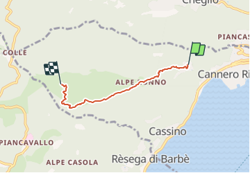
![](/images/other/stat-length.png)
![Tocht Te voet Cannero Riviera - R26 Oggiogno - Alpe Morissolo - Photo](https://media.geolcdn.com/t/1900/400/0a73e6db-5cec-4e0f-a4ad-b44e7765150a.jpeg&format=pjpeg&maxdim=2)
R26 Oggiogno - Alpe Morissolo
SityTrail - itinéraires balisés pédestres
Tous les sentiers balisés d’Europe GUIDE+
![Lengte](/images/other/stat-length.png)
![Max. hoogte](https://static1.geolcdn.com/siteimages/upload/files/1508320355ic_sort_altitude_max_24dp.png)
![Positief hoogteverschil](https://static1.geolcdn.com/siteimages/upload/files/1508320355ic_sort_den_pos_24dp.png)
![Km-Effort](/images/other/stat-length.png)
![Min. hoogte](https://static1.geolcdn.com/siteimages/upload/files/1508320355ic_sort_altitude_min_24dp.png)
![Negatief hoogteverschil](https://static1.geolcdn.com/siteimages/upload/files/1508320355ic_sort_den_neg_24dp.png)
![Boucle](https://static1.geolcdn.com/siteimages/upload/files/16400158638029165_repeat_loop_refresh_sync_direction_icon.png)
![Te voet](https://static1.geolcdn.com/sitytour/trail-icons/100.png)
2h30
Moeilijkheid : Gemakkelijk
![Scan deze QR-code om de tocht te openen in de SityTrail-applicatie](https://capi.geolives.com/qq0zvz2zws4bq2lad0pu/sitytour/trails/3123618/qr.png?size=200)
Gratisgps-wandelapplicatie
Over ons
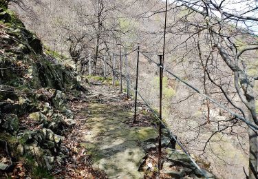
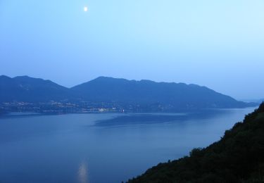
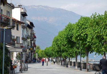
Tocht Te voet van 3,7 km beschikbaar op Piëmont, Verbano-Cusio-Ossola, Cannero Riviera. Deze tocht wordt voorgesteld door SityTrail - itinéraires balisés pédestres.
Beschrijving
Club Alpino Italiano Sezioni Est Monte Rosa - Associazione delle Sezioni del Club Alpino Italiano delle Province del Verbano Cusio Ossola e di Novara. Chi siamo, organigramma, storia, eventi e notizie; calendario escursioni sezionali con attività di alpinismo, alpinismo giovanile, escursionismo, sci alpinismo, ferrate, ciclo escursionismo, speleologia, cultura e tradizione; gallerie fotografiche; scuole di alpinismo, sci alpinismo, escursionismo, speleologia, alpinismo giovanile; itinerari escursionistici; sentieri, rifugi e bivacchi.
Plaatsbepaling
Opmerkingen
Wandeltochten in de omgeving
![Tocht Te voet Cannobio - S02b Cannobio Lignago - Sant'Agata - Campeglio - Photo](https://media.geolcdn.com/t/375/260/5c2c4b09-37af-4f00-bc6d-f934ad1fe9d5.jpeg&format=jpg&maxdim=2)
![Te voet Te voet](https://static1.geolcdn.com/sitytour/trail-icons/100.png)
Te voet
![](/images/other/stat-length.png)
![](https://static1.geolcdn.com/siteimages/upload/files/16400158638029165_repeat_loop_refresh_sync_direction_icon.png)
![Tocht Te voet Cannobio - S02 Cannobio - San Bartolomeo Valmara - Photo](https://media.geolcdn.com/t/375/260/3397c58e-fb3d-4ce7-8139-61dcd35c5e40.jpeg&format=jpg&maxdim=2)
![Te voet Te voet](https://static1.geolcdn.com/sitytour/trail-icons/100.png)
Te voet
![](/images/other/stat-length.png)
![](https://static1.geolcdn.com/siteimages/upload/files/16400158638029165_repeat_loop_refresh_sync_direction_icon.png)
![Tocht Te voet Cannobio - S07 Sant'Anna (Traffiume) - Pro Redond - Photo](https://media.geolcdn.com/t/375/260/cbf1b4c1-d59b-4eb2-b623-b3cbda57ec84.jpeg&format=jpg&maxdim=2)
![Te voet Te voet](https://static1.geolcdn.com/sitytour/trail-icons/100.png)
Te voet
![](/images/other/stat-length.png)
![](https://static1.geolcdn.com/siteimages/upload/files/16400158638029165_repeat_loop_refresh_sync_direction_icon.png)
![Tocht Te voet Cannobio - S05 Cannobio - Monte Carza - Photo](https://media.geolcdn.com/t/375/260/c20d7fb5-19f2-4ded-aa46-56255dc6e193.jpeg&format=jpg&maxdim=2)
![Te voet Te voet](https://static1.geolcdn.com/sitytour/trail-icons/100.png)
Te voet
![](/images/other/stat-length.png)
![](https://static1.geolcdn.com/siteimages/upload/files/16400158638029165_repeat_loop_refresh_sync_direction_icon.png)
![Tocht Te voet Cannobio - S01 Socraggiolo - Finero - Photo](https://media.geolcdn.com/t/375/260/b76c2232-6a39-4ce2-a274-a64823cf27f3.jpeg&format=jpg&maxdim=2)
![Te voet Te voet](https://static1.geolcdn.com/sitytour/trail-icons/100.png)
Te voet
![](/images/other/stat-length.png)
![](https://static1.geolcdn.com/siteimages/upload/files/16400158638029165_repeat_loop_refresh_sync_direction_icon.png)
![Tocht Te voet Cannero Riviera - R44 Cannero - Trarego - Photo](https://media.geolcdn.com/t/375/260/be747f0d-8683-47df-8dee-8f770302bc2f.jpeg&format=jpg&maxdim=2)
![Te voet Te voet](https://static1.geolcdn.com/sitytour/trail-icons/100.png)
Te voet
![](/images/other/stat-length.png)
![](https://static1.geolcdn.com/siteimages/upload/files/16400158638029165_repeat_loop_refresh_sync_direction_icon.png)
![Tocht Te voet Trarego Viggiona - R46 Molineggi - Viggiona - Trarego - Photo](https://media.geolcdn.com/t/375/260/5e34abd1-889a-486a-b6d0-6e83673b0515.jpeg&format=jpg&maxdim=2)
![Te voet Te voet](https://static1.geolcdn.com/sitytour/trail-icons/100.png)
Te voet
![](/images/other/stat-length.png)
![](https://static1.geolcdn.com/siteimages/upload/files/16400158638029165_repeat_loop_refresh_sync_direction_icon.png)
![Tocht Te voet Cannero Riviera - R28 Malpensata (Oggiogno) - Colle - Photo](https://media.geolcdn.com/t/375/260/5cc9e261-f063-4e0c-81a2-24bc12787a22.jpeg&format=jpg&maxdim=2)
![Te voet Te voet](https://static1.geolcdn.com/sitytour/trail-icons/100.png)
Te voet
![](/images/other/stat-length.png)
![](https://static1.geolcdn.com/siteimages/upload/files/16400158638029165_repeat_loop_refresh_sync_direction_icon.png)
![Tocht Te voet Cannobio - S00 Cannobio - Finero - Photo](https://media.geolcdn.com/t/375/260/a0b6d0c6-4d2d-4bdf-a029-b309849ab069.jpeg&format=jpg&maxdim=2)
![Te voet Te voet](https://static1.geolcdn.com/sitytour/trail-icons/100.png)
Te voet
![](/images/other/stat-length.png)
![](https://static1.geolcdn.com/siteimages/upload/files/16400158638029165_repeat_loop_refresh_sync_direction_icon.png)